Junfei Chena,b, Chao Lia, Albert Galyb, Hui Wanga, Chengfan Yanga, Shouye Yanga
a. State Key Laboratory of Marine Geology, Tongji University, Shanghai 200092, China
b. Centre de Recherches Pétrographiques et Géochimiques, UMR7358, CNRS, Université de Lorraine, 54500 Vandoeuvre les Nancy, France
Abstract
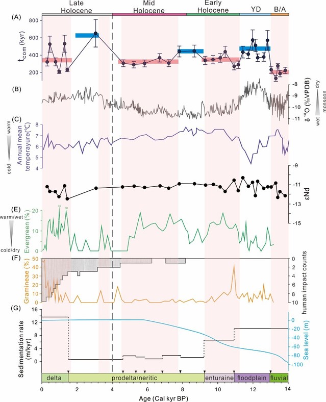
Catchment erosion not only plays an important role on landscape evolution, but also determines the exposure of rock debris in the regolith profile, and therefore impacts the chemical weathering and associated CO2 absorption and ultimately global climate. But climate also modulates erosion and complex interaction loops, especially at large scale can hamper a clear understanding of these processes. Here we mainly use Uranium-series Comminution Age (tcom) of core sediments from Changjiang estuary to reconstruct the catchment erosion, and the relationship with climate changes and human activities during the last ~14 kyrs.
Since 14 ka, the sea level has been rising continuously until current highstand system tract in the East China Sea where the Changjiang estuary is located. The sediments in the Changjiang estuary mainly come from the upper reaches erosion zone during this period, but the sediment supply from the middle and lower reaches has gradually increased since the Late Holocene. The period can be divided into two modes. The first mode happens from the Bølling–Allerød period to the mid-Holocene when the sea level rose rapidly, and the tcom of sediment recorded the residence time in the upper reaches erosion zone, with a periodic pattern of tcom in a good agreement with climate changes. During the cold and dry periods, the longer tcom (average 460 kyrs) is consistent with less precipitation resulting in shallower erosion with transported material mainly coming from the soil with longer residence time. In contrast, during the warm and wet periods, the tcom is shorter (average 290 kyrs), with the more abundant precipitations that contribute to deeper erosion in the upper catchment, and more fresh material transported to the estuary through stronger hydrodynamic forces. The second mode is more chaotic and corresponds to 0 to 4 ka, when climate was warm and humid and stable sea level, but tcom fluctuated from 200 kyrs to 650 kyrs. The increasing river flooding caused by abundant precipitation leads to lateral migration of the river channel in the middle and lower reaches, and the sediments deposited in the floodplain were eroded and mobilized again. In addition, the rapid development of human activities since 2 ka has accelerated deforestation and agricultural cultivation, leading to localized erosion of the floodplain. These remobilized sediments were transported to the estuary and deposited, resulting in a larger tcom value. This study overall indicates that, in the millennial scale, the tcom of fine detrital fraction shows a sensitive and quick response to catchment erosion, and provides new insights into quantifying the time scale of sediment source to sink processes and inferring the paleoenvironment accurately climate changes.
Full paper: https://doi.org/10.1016/j.epsl.2023.118493


